
|
|

|

|
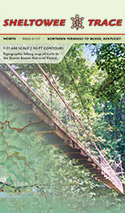 Sheltowee Trace Trail Map Sheltowee Trace Trail Map
1:31,680 scale map that shows the ST from the northern terminus to Burnt Mill Bridge in the Big South Fork National River and Recreation Area. Is available in the Sheltowee Trace North and South map sets.
Map contains mile makers for the ST, connecting trails for section hiking, 50-ft elevaiton contours, and GPS lat/lon grid. Full-color maps.
Current outrageGIS maps
North map: $14
South map: $20
Available laminated
ThruHiking Journals
Over the years a few folks have hiked the entire ST, sometimes more than once! They logged their trips with journals and offer them here for your reading. Thanks to their great reporting, we have a sense of the trail conditions and hiker experiences that we can't get anywhere else, expect on trail.
Jonaharalia
I. B. Me
Sheltowee Wanderer
Chester's Thru-Hike
Want
to blog your ST journey? View
this post
|
|

|
|

|
|
|
|
|
|
|
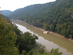
a photo from
the gallery
Photos from the Big Turtle Photo Club
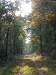
a photo from
the gallery
Mapping the Sheltowee Trace is forum and interactive map for The Sheltowee Trace. When we started mapping the ST it was
a 260-mile backcountry trail connecting recreation in Daniel Boone National
Forest, Cumberland Falls & Natural
Bridge State Resort Parks, and the Big South Fork National Recreation Area.
Over the subsequence 10 years, the ST has grown nearly 60 miles in length. This site is a record of that growth. outrageGIS mapping
creates trail maps and guides for backcountry camping and trail exploration.
|
|
|
|
|
|
|
|
|
|
|
|
|
|
Recent
Discussion
from the
Mapping the Sheltowee
A Guide for the Trails in the BSF and DBNF
• Veterans Day Hiking 2019
Author: twostep
Posted: Sat Nov 30, 2019 6:24 pm (GMT -5)
Started on a hike before realizing it was deer season.
https://www.youtube.com/watch?v=Elav8LvxRUo
Like, share and subscribe as well as follow us on facebook.
https://www.facebook.com/poboyadventures.ky/
Hope to see you on down the trail or river.
• What happened?
Author: Elkins45
Posted: Thu Mar 22, 2018 9:26 pm (GMT -5)
• Po'Boy Adventures
Author: twostep
Posted: Mon Mar 05, 2018 9:13 pm (GMT -5)
Check out https://poboyadventuresky.wixsite.com/poboyadventures for upcoming adventures hiking and kayaking.
See ya, on down the trail.
• Insanity 2016 (thru hike in 9 1/2 days)
Author: I.B.Me
Posted: Sun Mar 27, 2016 6:25 pm (GMT -5)
On Thursday night March 10th my son Chanse and I camped out at the Northern Terminus to get an early start on our thru hike. Chanse was on spring break so we only had 10 days to get as far as we could on the Sheltowee.
The weather had been unusually warm with nighttime lows in the mid 50's. The mild temps allowed us to lighten our packs with thinner sleeping bags and less clothing. We carried homemade backpacks and minimalistic gear to allow for a faster pace. Our packs weighed 26 pounds each including food and water.
The trail was in much better shape than when I last thru hiked it in 2009. The first day we started at 05:20 and ... continues
• Need Help - Parking in / near Arvel
Author: oxidane
Posted: Tue Mar 08, 2016 3:50 pm (GMT -5)
We are planning to do a section between Arvel and Sparks Ridge Rd. Parts of Sections 19 & 20.
-Are there any places to park in Arvel or anyone to contact about said parking? Mile marker 120.
-Also, another group may be looking to intersect us on the first night and thought about parking at or near Mt. Bethel Church.
-Finally ending at Lime Kiln/Hwy-89 and parking at the power line right of way there. Thoughts? Mile Marker 132.5
Thanks in advance.
• spam on site
Author: Ewker
Posted: Thu Sep 03, 2015 10:13 am (GMT -5)
someone needs to delete all of these spam post and block the guy posting them.
_________________
Conquest: It is not the Mountain we conquer but Ourselves
• Change on SheltoweeTrace.com
Author: Boyd
Posted: Sat Jun 06, 2015 10:31 pm (GMT -5)
Big changes are happening!
In an effort to keep the ST accessible via mobile, we made a new map.
The site landing page is a google-style map that you can use to locate your position in the field, if you have a smart phone and a data connection. You can't search it like google map, but it does show the current alignment of the ST.
Is the map useful? Is this forum hard to find or use?
Considering the multiple ways people connect to information these days, this forum is becoming less used and maintained. The trail on the ground however is exploding with use.
While this forum will always exist (especially as an archive... continues
|
|
|
|
|
|